
Volumetric Stockpile Drone Survey
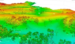
Project Objectives High Exposures was commissioned to conduct a LiDAR survey on an 800-meter section of the Nepean River. The objective of this survey was
Project Objectives High Exposures was commissioned to conduct a LiDAR survey on an 800-meter section of the Nepean River. The objective of this survey was
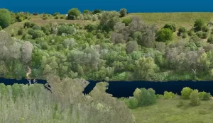
Project Objectives High Exposures was commissioned to conduct a LiDAR survey on an 800-meter section of the Nepean River. The objective of this survey was
Project Objectives A 340ha parcel of land, located one hour west of Sydney, was assessed by developers for a preliminary development application. High Exposure was